shopblog.nl
Categorieën
  Sluiten

Meer Kartografija
Meer Kartografija in Thrillers & fantasy boeken

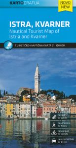
Wegenkaart - landkaart - Fietskaart Istrië - Kvarner | Kartografija

Goede kaart van Istrië en het noordelijk deel van de Kroatische kust. Op een behoorlijke schaal, geschikt voor aurto en fietsers is het gebied met helder leesbare kleuren mooi op kaart gezet. Met symbolen worden de toeristische zaken als bezienswaardigheden weergegeven, maar ook campings en havens.   Istria and Kvarner, the northern part of Croatia...
12,95

Webshops met dit product

Webshop
Bezorging
Prijs

Anderen bekeken ook

Wegenkaart - landkaart - Fietskaart Istrië - Kvarner | Kartografija
Goede kaart van Istrië en het noordelijk deel van de Kroatische kust. Op een behoorlijke schaal, geschikt voor aurto en fietsers is het gebied met helder leesbare kleuren mooi op kaart gezet. Met symbolen worden de toeristische zaken als bezienswaardigheden weergegeven, maar ook campings en havens.   Istria and Kvarner, the northern part of Croatia’s Adriatic coast, at 1:100,000 on a detailed, GPS compatible double-sided road map from Kartografija in Ljubljana highlighting picturesque locations. On one side is Istria with coverage extending north to Trieste - on the reverse the map shows the northern part of the Adriatic coast and its islands, extending south to cover all but the southernmost tip of Lošinj and approximately half of Pag.    Topography is shown by relief shading with contours at 40m intervals. Road network includes small local roads and selected cart tracks. Driving distances are shown on main and most secondary routes, and locations of border crossings and petrol statio…
12,95
Wegenkaart - landkaart - Fietskaart Dalmatië - Dalmacija kaartenset |
Goede wegenkaart met veel details: daardoor als fietskaart ook uitstekend te gebruiken. Naast de gewone geografische gegevens worden met symbolen veel toeristische mogelijkheden weergegeven, ook campings staan er op.   The Dalmatian Coast of the Adriatic on a set of two double-sided road maps at 1:100,000 from the Ljubljana-based Kartografija with good presentation of the topography of the islands and of the adjoining mainland, car ferry connections, etc. Coverage starts from the central part of Pag and on the mainland from north of Karlobag, so please note that the northern islands (Krk, Cres Rab and Lošoi) are not included.    Bold altitude colouring with relief shading and contour lines shows the topography. Road network includes cart tracks, shows locations of petrol stations and gives driving distances on main and many local roads. Also shown are selected footpaths, indicating waymarked routes. Railway lines are shown with stations and car ferry routes are also marked. Symbols ind…
12,95
Wegenkaart - landkaart 3327 Adventure Map Western Balkans - Westelijke
Wegenkaart van de Westelijke Balkan met vermelding van veel bezienswaardigheden en attrakties. Watervast en scheurvast. Juist door deze vermeldingen onderscheidt de kaart zich van andere wegenkaarten. Landen: Slovenië, Kroatië, Bosnië Herzegovina, Montenegro, Albanië, Servië,  Kosovo, and Macedonië.   The Western Balkans region, an adventure playground and rising star of Europe, is loaded with Old World traditions, slow food culture, ancient towns, and rarely visited villages. The area stretches from the Adriatic Sea in the west, up and over mountain ranges, raging rivers, tectonic lakes, steep gorges, and thousands of miles of paths, trails, and routes. Discover eight countries—all with their special brand of Balkan magic: Slovenia, Croatia, Bosnia and Herzegovina, Montenegro, Albania, Serbia, Kosovo, and Macedonia.   National Geographic's Western Balkans Adventure Map will meet the needs of travelers with its detailed and accurate information. The map includes the locations of UNESCO…
17,50
Wegenkaart - landkaart - Fietskaart Crnogorsko primorje - Kust van Mon
Mooie duidelijke kaart van de kust van Montenegro met symbolen als havens, campings en ook afstadnen en hoogtes. Gemarkeerde wandelpaden staan keurig ingetekend.   The coast of Montenegro at 1:100,000 on a detailed, contoured and GPS compatible road map from Kartografija in Ljubljana, with on the reverse bilingual descriptions of numerous places of interest illustrated with colour photographs.    The map has contours at 40m intervals plus altitude colouring and relief shading, with spot heights for local peaks. Road network includes country tracks, shows locations of petrol stations and gives distances on main and on selected smaller routes. Railway lines are marked, and the map also highlights selected local hiking trails. Picturesque locations are prominently highlighted and symbols indicate various places of interest, campsites and nudist camps, etc. Also marked are coastal locations with marinas, yachting harbours and nautical fuel supplies.    The reverse side is covered with bili…
12,95
Wegenkaart - landkaart 3014 Adventure Map India South - Zuid | Nationa
Wegenkaart van Zuid India met vermelding van veel bezienswaardigheden, nationale parken en attrakties. Watervast en scheurvast. National Geographic's India South Adventure Map is designed to meet the unique needs of adventure travelers with its durability and detailed, accurate information. The map includes the locations of thousands of cities and towns with a user-friendly index, as well as a clearly marked road network complete with distances and designations for highways, major routes and secondary roads.   The India South Adventure Map differs from a traditional road map for it includes hundreds of points of interest that highlight the diverse and unique destinations found in this region. The map features UNESCO World Heritage sites, archaeological sites, wildlife sanctuaries, Hindu and Buddhist temples, sacred sites, forts, palaces, ruins, waterfalls, caves and other points of interest, making it an invaluable resource to travelers hoping to experience all the history and culture …
17,50
Wegenkaart - landkaart 3008 Adventure Map China East - Oost | National
Wegenkaart van Oost China  met vermelding van veel bezienswaardigheden, nationale parken en attrakties. Watervast en scheurvast.   National Geographic's China East Adventure Map is designed to meet the unique needs of adventure travelers with its durability and detailed, accurate information. The map includes the locations of thousands of cities and towns with a user-friendly index, plus a clearly marked road network complete with distances and designations for major highways, major routes and secondary roads. The China Adventure Map is printed in the United States on a durable synthetic paper, making it waterproof, tear-resistant and tough—capable of withstanding the rigors of international travel.   The China East Adventure Map differs from a traditional road map for it includes hundreds of points of interest that highlight diverse and unique destinations in the region. UNESCO World Heritage sites, national parks and reserves, archaeological sites, temples, caves and points of in…
17,50

Klanten-reviews van Wegenkaart - landkaart - Fietskaart Istrië - Kvarner | Kartografija

Er zijn nog geen beoordelingen voor dit productBen jij de eerste die een review plaatst?

Meer over Wegenkaart - landkaart - Fietskaart Istrië - Kvarner | Kartografija

Productomschrijving

Goede kaart van Istrië en het noordelijk deel van de Kroatische kust. Op een behoorlijke schaal, geschikt voor aurto en fietsers is het gebied met helder leesbare kleuren mooi op kaart gezet. Met symbolen worden de toeristische zaken als bezienswaardigheden weergegeven, maar ook campings en havens.   Istria and Kvarner, the northern part of Croatia’s Adriatic coast, at 1:100,000 on a detailed, GPS compatible double-sided road map from Kartografija in Ljubljana highlighting picturesque locations. On one side is Istria with coverage extending north to Trieste - on the reverse the map shows the northern part of the Adriatic coast and its islands, extending south to cover all but the southernmost tip of Lošinj and approximately half of Pag.    Topography is shown by relief shading with contours at 40m intervals. Road network includes small local roads and selected cart tracks. Driving distances are shown on main and most secondary routes, and locations of border crossings and petrol stations are also marked. Railway lines are included and ferry routes are marked. An overprint highlights numerous recommended cycling routes.    Pictureque locations are prominently highlighted and symbols indicate various places of interest including ordinary or nudist campsites, beaches, viewpoints, historical sites, etc. Along the coast symbols indicate marinas, harbours, anchor facilities for large craft, etc. The map also gives some bathymetric information but is not intended to be used as a sailing chart. The map has no index. Map legend includes English.

Productspecificaties

Artikelnummer(s)
Brand
Kartografija

Verken gerelateerde categorieën

Shopblog.nl maakt gebruik van cookies. Ga je verder op onze website, ga dan akkoord met het plaatsen van cookies en de verwerking van deze data door ons en vermelde partners.