shopblog.nl
Categorieën
  Sluiten

Meer Harvey Maps

Wandelkaart Thames Path | Harvey Maps

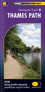
Mooie, duidelijke kaart van het Thames Path in Engeland. Geplastificeerd met veel extra informatie en uitsnedes van de route.   Thames Path National Trail   The Thames Path follows the banks of the river for 184 miles (294KM) from the flood barrier at Woolwich in South East London to Kemble Gloucestershire. It is a long distance walking route, most...
25,95

Webshops met dit product

Webshop
Bezorging
Prijs

Anderen bekeken ook

Wandelkaart Thames Path | Harvey Maps
Mooie, duidelijke kaart van het Thames Path in Engeland. Geplastificeerd met veel extra informatie en uitsnedes van de route.   Thames Path National Trail   The Thames Path follows the banks of the river for 184 miles (294KM) from the flood barrier at Woolwich in South East London to Kemble Gloucestershire. It is a long distance walking route, most of it cannot be cycled. The Trail passes through water meadows, historic towns & lovely villages. The path is flat which makes for easy walking. Jos Joslin National Trails Manager (Marketing & Projects) said of this map "Really beneficial to have the whole length of the Thames Path upstream of London on just one map. Clear mapping and useful information makes this a very practical map"   XT40 New generation of tough polyethylene maps   The HARVEY series of Long Distance Route maps is an established success. Now the advanced technology used in the creation of our best-selling British Mountain Maps is also applied to the route maps.   These ma…
25,95
Wandelgids Thames Path | Trailblazer Guides
This book follows the Thames Path National Trail from the river's source in Gloucestershire to the Thames Barrier in London. Officially 184 miles (294km) in length (although the actual distance you walk will depend on a number of decisions you make en route), the path meanders, accompanied by its watery muse, through pristine and tranquil countryside, past historic sites and buildings, via pub, lock, weir, and the occasional scattering of waterfowl, to a city, once the fulcrum of an empire, and now the heart of modern day England. The river, responsible for the metropolis' very being, tells tales, inspires artists, accommodates swans, geese, and water voles, reflects the silhouettes of red kites and kingfishers, provides employment, entices adventure, and allows time for carefree pilgrims to procrastinate and think. Following its banks is a grand way to go for a ramble. The path begins, as the river does, in a meadow in the Cotswolds; its upper reaches lonely and wild, the meadows and …
19,95
Wandelgids Walking in the Thames Valley | Cicerone
Walking in the Thames Valley offers 25 challenging circular walks around the River Thames and River Kennet in the south of England, taking in the Southern Chilterns, the Berkshire and North Hampshire Downs, Southern Oxfordshire and the eastern edge of Wiltshire. All routes are within easy reach of Reading, Newbury, Abingdon and London. While some walks visit Iron Age hill forts, others pass more modern features such as Wilton Windmill and the Kennet and Avon Canal. Some follow sections of the Ridgeway, while others meander along the banks of the Thames. What they all have in common is that they take the keen rambler to some of the best parts of the Thames Valley – a patchwork of open chalk grassland, broadleaved woodland and farmland and home to two Areas of Outstanding Natural Beauty. • walks from 10 to 18 miles, including one 2-day route • shorter, less strenuous alternatives for many of the walks • detailed route descriptions with information on local points of interest, OS mapping …
18,50
Wandelkaart St Oswald's Way | Harvey Maps
Mooie, duidelijke kaart van de St Oswald's Way Noord-Engeland. Geplastificeerd met veel extra informatie en uitsnedes van de route.   From Holy Island to Heavenfield, the 97 mile St Oswald's Way links some of the places associated with St Oswaldwho was the King of Northumbria in the early 7th century. The route runs through the Northumbria National Park following the stunning Northumberland Coast before heading inland across beautiful countryside to Heavenfield. It links with St Cuthbert's Way in the north and Hadrian's Wall Path in the south. Along the way you will encounter rolling farmland, villages, vast sandy beaches and fascinating history.   The HARVEY series of Long Distance Route maps is an established success. Now the advanced technology used in the creation of our best-selling British Mountain Maps is also applied to the route maps.   These maps are a leap forward in technical excellence. They are tough, durable, light and 100% waterproof - virtually indestructible in normal…
25,95
Wandelgids Walking in the Thames Valley | Cicerone
Walking in the Thames Valley offers 25 challenging circular walks around the River Thames and River Kennet in the south of England, taking in the Southern Chilterns, the Berkshire and North Hampshire Downs, Southern Oxfordshire and the eastern edge of Wiltshire. All routes are within easy reach of Reading, Newbury, Abingdon and London. While some walks visit Iron Age hill forts, others pass more modern features such as Wilton Windmill and the Kennet and Avon Canal. Some follow sections of the Ridgeway, while others meander along the banks of the Thames. What they all have in common is that they take the keen rambler to some of the best parts of the Thames Valley – a patchwork of open chalk grassland, broadleaved woodland and farmland and home to two Areas of Outstanding Natural Beauty. • walks from 10 to 18 miles, including one 2-day route • shorter, less strenuous alternatives for many of the walks • detailed route descriptions with information on local points of interest, OS mapping …
18,50
Wandelgids The Thames Path | Cicerone
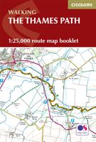
All the mapping you need to complete the 182 mile (290km) Thames Path National Trail, from the Woolwich Foot Tunnel in London to the river's source in Gloucestershire. This booklet is included with the Cicerone guidebook to the Thames Path, where the route is divided into 20 stages, with each stage ranging from 4 to 16 miles. This gentle riverside walk takes roughly two weeks to complete.   This booklet of Ordnance Survey 1:25,000 Explorer maps has been designed for convenient use on the trail. It shows the full and up-to-date line of the National Trail, along with the relevant extract from the OS Explorer map legend. Conveniently sized for slipping into a jacket pocket or top of a rucksack and provides all the mapping needed to complete the trail.   Passing through London, Windsor and Oxford as well as rural countryside, this National Trail offers walkers a diverse range of landscapes and scenery. With excellent public transport services at each stage, this trail can also be completed…
18,50
Wandelkaart Adventure Atlas Hadrian's Wall Path | A-Z Map Company
AZ heeft de meest gedetailleerde wandelkaarten van het Hadrian's Wall Path gebundeld in een atlasje. Daardoor is het heel handig qua formaat. De kaarten zelf zijn perfect voor het wandelen. Schaal 1:25.000 The A-Z Adventure Series of maps combines the best of OS and A-Z, creating the perfect companion for walkers, off-road cyclists, horse riders and anyone wishing to explore the great outdoors. Hadrian's Wall Path is a National Trail which follows the line of Hadrian's Wall from coast-to-coast. The 84 mile (135km) path weaves through beautiful countryside, encountering historic remains of Roman forts and milecastles, splendid bridges, views from the Whin Sill escarpment and Solway salt marshes. Starting in Wallsend in Newcastle and ending in Bowness-on-Solway, the route on the map is clearly highlighted in yellow with mileage markers added to guage distances when planning sections of the walk to enjoy. This official National Trail Map of Hadrian's Wall Path features 38 pages of continu…
12,95
Wandelgids The Thames Path | Cicerone
All the mapping you need to complete the 182 mile (290km) Thames Path National Trail, from the Woolwich Foot Tunnel in London to the river's source in Gloucestershire. This booklet is included with the Cicerone guidebook to the Thames Path, where the route is divided into 20 stages, with each stage ranging from 4 to 16 miles. This gentle riverside walk takes roughly two weeks to complete.   This booklet of Ordnance Survey 1:25,000 Explorer maps has been designed for convenient use on the trail. It shows the full and up-to-date line of the National Trail, along with the relevant extract from the OS Explorer map legend. Conveniently sized for slipping into a jacket pocket or top of a rucksack and provides all the mapping needed to complete the trail.   Passing through London, Windsor and Oxford as well as rural countryside, this National Trail offers walkers a diverse range of landscapes and scenery. With excellent public transport services at each stage, this trail can also be completed…
18,50

Klanten-reviews van Wandelkaart Thames Path | Harvey Maps

Er zijn nog geen beoordelingen voor dit productBen jij de eerste die een review plaatst?

Meer over Wandelkaart Thames Path | Harvey Maps

Productomschrijving

Mooie, duidelijke kaart van het Thames Path in Engeland. Geplastificeerd met veel extra informatie en uitsnedes van de route.   Thames Path National Trail   The Thames Path follows the banks of the river for 184 miles (294KM) from the flood barrier at Woolwich in South East London to Kemble Gloucestershire. It is a long distance walking route, most of it cannot be cycled. The Trail passes through water meadows, historic towns & lovely villages. The path is flat which makes for easy walking. Jos Joslin National Trails Manager (Marketing & Projects) said of this map "Really beneficial to have the whole length of the Thames Path upstream of London on just one map. Clear mapping and useful information makes this a very practical map"   XT40 New generation of tough polyethylene maps   The HARVEY series of Long Distance Route maps is an established success. Now the advanced technology used in the creation of our best-selling British Mountain Maps is also applied to the route maps.   These maps are a leap forward in technical excellence. They are tough, durable, light and 100% waterproof - virtually indestructible in normal use.   They are light to carry, and compact - not the great bulky package you get with a laminated map.   The map is detailed, with the routes clearly marked. It also contains general information, useful telephone numbers and a full key.

Productspecificaties

Artikelnummer(s)
Brand
Harvey Maps
Shopblog.nl maakt gebruik van cookies. Ga je verder op onze website, ga dan akkoord met het plaatsen van cookies en de verwerking van deze data door ons en vermelde partners.