shopblog.nl
Categorieën
  Sluiten

Stadsplattegrond - Wegenkaart - landkaart Dubrovnik & Croatian Coast C

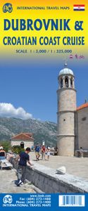
Goede plattegrond van Dubrovnik, schaal 1:3.000. Met aan de achterzijde een wegenkaart, schaal 1:325.000, met als extra informatie routes van veerboten en cruiseschepen ingetekend.   The ancient port city of Dubrovnik, on the southern Croatian coastline, has evolved into a major tourist destination. The old walled city, normally entered through the...
13,95

Webshops met dit product

Webshop
Bezorging
Prijs

Anderen bekeken ook

Stadsplattegrond - Wegenkaart - landkaart Dubrovnik & Croatian Coast C
Goede plattegrond van Dubrovnik, schaal 1:3.000. Met aan de achterzijde een wegenkaart, schaal 1:325.000, met als extra informatie routes van veerboten en cruiseschepen ingetekend.   The ancient port city of Dubrovnik, on the southern Croatian coastline, has evolved into a major tourist destination. The old walled city, normally entered through the famous Pile Gate, was so crowded with tourists when we arrived, that it took some time to get to the main street of Stradun. The city has completely recovered from the Montenegrin bombing during the breakup of Yugoslavia, with a few shellholes remaining just to show to tourists. The highlights of a visit are the Rector’s Palace, the Tvrdava fortress, and the cathedral. The map covers the urban area outside of the old town as well, as this is where most of the hotels and restaurants are located. The other side of the map shows the extensive coastline of Croatia in two parts – from the Italian border to Trogir, and from Split to the border wit…
13,95
Wegenkaart - landkaart Slovenie - Slovenia & Croatian coast | ITMB
ITMB have visited Slovenia several times and find it to be an interesting and scenic part of Europe with modern and well-maintained hotels, restaurants and roads, with prices being much more affordable than in neighbouring countries to the west. As the country is not particularly large, we have limited our country coverage to one side of the sheet, with a detailed inset map of Ljubljana. The other side is a lovely map of the Dalmatian Coast. Now that Croatia is part of the EU, border limitations with the rest of western Europe have been removed and driving from Italy or Slovenia southward towards Dubrovnik is easy. The map shows the Pula Peninsula, the coastal islands of Cres, Brac, and Havar, and resort communities such as Zadar, Split, and medieval Dubrovnik. The new coastal motorway is mostly complete, but political difficulties are forcing an expensive tunneling project to by-pass part of Bosnia. Once completed, the highway will stretch to the Montenegrin border and become a major …
13,95
Wegenkaart - landkaart Mauritania & Mali | ITMB
Een degelijke kaart met aanduidingen van o.a. nationale parken, vliegveld, benzinepomp, dirt-roads en kleine plattegrond van hoofdstad. Als overzichtskaart goed te gebruiken. Mali 1:1.900.000 Mauretanië 1:2.200.000 In this edition, we have combined Mauritania with Mali. Although both are interesting countries, the two fit naturally together as a unit, albeit at slightly differing scales. Technically, this should be a 1st edition map, as it is the first time we have combined these two desert countries on to one sheet, but I ll let Robert at the Library of Congress worry about the niceties of bibliographic accuracy as soon as Trump allows him to do the work he loves for a salary. Mauritania was one of the most unusual countries I visited as a young traveller. Of course, I had an advantage, in that I was too young to know that what I was doing was supposed to be impossible. I entered from what was then the Spanish Sahara via a piste (a sandy track with multiple pathways, only some of whic…
13,95
Wegenkaart - landkaart - Stadsplattegrond Toronto & Southern Ontario -
Overzichtskaart van het zuiden van Ontario - schaal 1:600.000 - met op de andere kant een grote plattegrond van Toronto op schaal 1:12.000 Legend Includes: Roads by classification, Accomodations, Museum, Churches, Buildings, Points of tourist, Public Interests, Post Offices, Police Stations, Schools, Live Theatres, Cinemas, Ruins, Bus Terminals, Ferry Terminals, Service Areas, Hospitals, Ports, Mines, RCMP, Major Airports, Secondary Airports, Camp Grounds, National Park and Equivalent Reserves, Ski, Picnic Sites, and much more.   Toronto is the largest city in Canada by far. Touristically, its attraction rests with its central core, from High Park in the west to the Don River in the east, and from the park-like islands in Lake Ontario to Bloor Street in the north. In this area, one finds remnants of the oldest portion of ‘muddy York’, the original fort built to deter American raiders (close to the exhibition grounds), Campbell House (at Queen & University), and the first public school…
13,95
Reisgids Top 10 Dubrovnik | Eyewitness
Nicknamed the "Pearl of the Adriatic", Dubrovnik offers culture and history in spades. At the same time, the surrounding Dalmatian Coast is a region of great natural beauty, with mile upon mile of serene coastline.   Make the most of your trip to this region of Croatia with DK Eyewitness Top 10. Planning is a breeze with our simple lists of ten, covering the very best that Dubrovnik and the Dalmatian Coast have to offer and ensuring that you don't miss a thing. Best of all, the pocket-friendly format is light and easily portable, the perfect companion while out and about.   Inside you'll find:   - Top 10 lists of Dubrovnik and the Dalmatian Coast's must-sees, including the Old City, Split, and the Dalmatian Islands, including Hvar and Vis. - Dubrovnik and the Dalmatian Coast's most interesting areas, with the best places for sightseeing, food and drink, and shopping - Themed lists, including the best sailing routes, cathedrals, beaches, restaurants and much more - Easy-to-follow itiner…
12,50
Reisgids - Wandelgids Explore Dubrovnik | Insight Guides
Handzame gids met de top bezienswaardigheden van Dubrovnik plus informatie over restaurants, hotels en het nachtleven. Daarnaast staan er elf wandelingen in de stad en de omgeving beschreven. Insight Explore Guides: pocket-sized books to inspire your on-foot exploration of top international destinations. Now with free eBook. Experience the best of Dubrovnik with this indispensably practical Insight Explore Guide. From making sure you don't miss out on must-see attractions like the old historic centre to discovering hidden gems like the sleepy harbour of Sudurad, the easy-to-follow, ready-made walking routes will help you plan your trip, save you time, and enhance your exploration of this fascinating city. - Practical, pocket-sized and packed with inspirational insider information, this will make the ideal on-the-move companion to your trip to Dubrovnik - Enjoy over 11 irresistible Best Routes to walk, from a tour of the old city walls to exploring the stunning islands of Lokrum and Mlj…
13,95
Reisgids Marco Polo ENG Dubrovnik and Dalmatian Coast | MairDumont
Handige en overzichtelijke, kleine reisgids voor een eerste kennismaking met de vakantiebestemming. Globale uitklapkaart achterin, makkelijk binnenzakformaat. Let Marco Polo Croatia Coast guide you around this beautiful coastline. Explore the Croatia Coast with this handy, pocket-sized, authoritative travel guide, packed with Insider Tips. Discover boutique hotels, authentic restaurants, the region’s trendiest places, and get tips on shopping and what to do on a limited budget.   There are also lots of ideas for travel with kids. Let Marco Polo show you all that Croatia Coast has to offer. The Croatia Coast with Dalmatia, Dubrovnik and Split is a holiday paradise, transformed by world-class hotels, elegant restaurants and a vibrant nightlife.   Let Marco Polo show you around one of the top destinations in the Adriatic. The calm, often austere beauty of the islands and bays, the crystal-clear water, the romantic settings of medieval harbour towns full of historical gems are just …
13,95
Wegenkaart - landkaart Mauritania & Mali | ITMB
Een degelijke kaart met aanduidingen van o.a. nationale parken, vliegveld, benzinepomp, dirt-roads en kleine plattegrond van hoofdstad. Als overzichtskaart goed te gebruiken. Mali 1:1.900.000 Mauretanië 1:2.200.000 In this edition, we have combined Mauritania with Mali. Although both are interesting countries, the two fit naturally together as a unit, albeit at slightly differing scales. Technically, this should be a 1st edition map, as it is the first time we have combined these two desert countries on to one sheet, but I ll let Robert at the Library of Congress worry about the niceties of bibliographic accuracy as soon as Trump allows him to do the work he loves for a salary. Mauritania was one of the most unusual countries I visited as a young traveller. Of course, I had an advantage, in that I was too young to know that what I was doing was supposed to be impossible. I entered from what was then the Spanish Sahara via a piste (a sandy track with multiple pathways, only some of whic…
13,95
Wegenkaart - landkaart 3019 Adventure Map Turkey Mediterranean Coast T
Wegenkaart van de zuidelijke kust van Turkije met vermelding van veel bezienswaardigheden, nationale parken en attrakties. Watervast en scheurvast.   National Geographic's Turkey, Mediterranean Coast Adventure Map is designed to meet the unique needs of adventure travelers with its durability and accurate information. This folded map provides global travelers with the perfect combination of detail and perspective, highlighting hundreds of points of interest and the diverse and unique destinations within the country.   The front side of the Turkey Mediterranean Coast map details the southern coastal region of the country. This side shows the Mediterranean Sea to the south and Syria to the east. The coastline extends from Kas to Iskenderum. The reverse side of the map details Turkey’s western coastal region of the country and its border with Greece and Bulgaria. This side shows the western coast from the Sea of Marmara down to the Mediterranean Sea. The map includes the locations of citi…
17,50

Klanten-reviews van Stadsplattegrond - Wegenkaart - landkaart Dubrovnik & Croatian Coast C

Er zijn nog geen beoordelingen voor dit productBen jij de eerste die een review plaatst?

Meer over Stadsplattegrond - Wegenkaart - landkaart Dubrovnik & Croatian Coast C

Productomschrijving

Goede plattegrond van Dubrovnik, schaal 1:3.000. Met aan de achterzijde een wegenkaart, schaal 1:325.000, met als extra informatie routes van veerboten en cruiseschepen ingetekend.   The ancient port city of Dubrovnik, on the southern Croatian coastline, has evolved into a major tourist destination. The old walled city, normally entered through the famous Pile Gate, was so crowded with tourists when we arrived, that it took some time to get to the main street of Stradun. The city has completely recovered from the Montenegrin bombing during the breakup of Yugoslavia, with a few shellholes remaining just to show to tourists. The highlights of a visit are the Rector’s Palace, the Tvrdava fortress, and the cathedral. The map covers the urban area outside of the old town as well, as this is where most of the hotels and restaurants are located. The other side of the map shows the extensive coastline of Croatia in two parts – from the Italian border to Trogir, and from Split to the border with Montenegro. We travelled from Porec to Dubrovnik in a small cruise ship of 45 passengers, which enabled us to visit ports that larger ships could not reach. As a result, we visited islands we could not have otherwise visited. The cover picture shows grandson Johnny in one such small town.   Legend Includes: Roads by classification, Rivers and Lakes, National Park, Airports, Points of Interests, Highways, Main Roads, Zoos, Fishing, and much more...
Shopblog.nl maakt gebruik van cookies. Ga je verder op onze website, ga dan akkoord met het plaatsen van cookies en de verwerking van deze data door ons en vermelde partners.