shopblog.nl
Categorieën
  Sluiten

Meer NGI - Nationaal Geografisch Instituut
Meer NGI - Nationaal Geografisch Instituut in Literatuur boeken

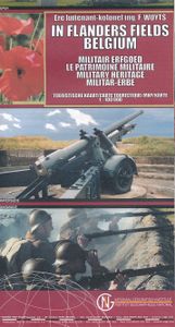
Historische Kaart Militair Erfgoed - In Flanders fields Belgium | NGI

Kaart voor militair erfgoed in West Vlaanderen, zowelvoor WO l als voor WO ll. The Western Front in Flanders on a detailed map at 1:100,000 highlighting locations of numerous monuments, cemeteries, front lines and other WWI-related sites, listed in the accompanying panels with, where appropriate, their phone numbers. The map is double-sided but all...
8,50

Webshops met dit product

Webshop
Bezorging
Prijs

Anderen bekeken ook

Historische Kaart Militair Erfgoed - In Flanders fields Belgium | NGI
Kaart voor militair erfgoed in West Vlaanderen, zowelvoor WO l als voor WO ll. The Western Front in Flanders on a detailed map at 1:100,000 highlighting locations of numerous monuments, cemeteries, front lines and other WWI-related sites, listed in the accompanying panels with, where appropriate, their phone numbers. The map is double-sided but all the main WWI battlefields from the French border to beyond Passendale/Paschendaele are together on one side.   The map shows the present-day road and rail networks in the province of West Flanders. Extensive overprint highlights locations of WWI-related sites, indicating whether open to the general public or by appointment only: museums, military cemeteries, war memorials and monuments to the missing soldiers, bunkers and battery remains, etc. Sites in France in the immediate vicinity of the Belgian border are also marked. The overprint also indicates battlefields and fortifications from other periods of history of Flanders, from the Middle …
8,50
Historische Kaart 14 - 18 Map of Verdun (Battlefield map) | Eerste Wer
Comprehensive mapping for the Battle of Verdun 1916 and a sizable part of the early days of the Meuse-Argonne Offensive 1918. Clearly produced in full color, with different types of feature in different colors, all supported by two comprehensive keys. For many years the Holts have provided tourers to the battlefields with excellent mapping for the Ypres Salient and the Somme. This map of the Verdun/Meuse area fills one of the many gaps in the coverage of the Western Front. This map of the Verdun battlefield is in the same style, using a color coded system to distinguish the different types of features. It includes some 300 locations of memorials, cemeteries, significant remnants of the battle terrain, remaining fortifications, trenches, the destroyed villages and other vestiges of the war. On the reverse there is a cut out and enlarged section of the Verdun battlefield in particular - the most visited part of the area, which provides greater detail. This section includes the Ossuary …
7,95
Historische Kaart Verdun - Eerste Wereldoorlog | War travel
Themakaart over de geschiedenis van de Eerste Wereldoorlog in en rond Verdun. Met gedetailleerde inzetten van Verdun, Argonne en Saint-Michel. Aandacht voor monumenten, musea, vestingen, loopgraven en kerkhoven.  Mooi kleurgebruik, veel detail en heel gedetailleerd. Gedrukt op stone-paper, dat gaat echt veel langer mee.   Van de uitgever Discover Verdun and its surroundings. This double-sided printed map shows the locations of cemeteries, monuments, forts, trenches and museums in and around Verdun. The map is printed on Stone Paper, 100% water-repellent, very durable in use and paper-free. Folded size 12.5 * 25 cm, unfolded 70 * 100 cm.   Discover 10 destroyed villages, 66 World War I cemeteries (37 French, 28 German and 1 American), 30 fortresses, 40 monuments, 16 trenches and 10 World War I museums using this highly detailed map.   The map is divided into 4 sections:   The city of Verdun. Visit the underground Citadelle, the beautiful Victory Monument, the old town in Vauban style an…
15,-
Historische Kaart Major & Mrs Holt's Battle Map of The Somme | Pen and
This is the only map available that shows the exact locations of 300 memorials and places of interest on the battlefields of the Somme   This Sixth Edition also covers the American and Canadian areas between Amiens and Montdidier.    It is double sided in four colours with an overall view on one side and a detailed view on the other, both showing battle lines and ORBAT information   There are detailed alphabetical and thematic indexes to all 300 points.   Size - The map measures 19.5 inches (49cm) by 28 inches (71cm). It is printed in four colours and is double sided on firm glossy paper.   On one side at a scale of 1:70,000 is shown the whole of the Somme battle area from Bullecourt in the north to Amiens in the south and from Doullens in the west to Pyronne in the east. Also on this side are the colour coded indexes and the map of the 1918 sector from Villers Bretonneux to Cantigny.   On the other side at a scale of 1:40,000 the battle area mostly, but not exclusively, associate…
9,95
Historische Kaart 14 - 18 Map of Verdun (Battlefield map) | Eerste Wer
Comprehensive mapping for the Battle of Verdun 1916 and a sizable part of the early days of the Meuse-Argonne Offensive 1918. Clearly produced in full color, with different types of feature in different colors, all supported by two comprehensive keys. For many years the Holts have provided tourers to the battlefields with excellent mapping for the Ypres Salient and the Somme. This map of the Verdun/Meuse area fills one of the many gaps in the coverage of the Western Front. This map of the Verdun battlefield is in the same style, using a color coded system to distinguish the different types of features. It includes some 300 locations of memorials, cemeteries, significant remnants of the battle terrain, remaining fortifications, trenches, the destroyed villages and other vestiges of the war. On the reverse there is a cut out and enlarged section of the Verdun battlefield in particular - the most visited part of the area, which provides greater detail. This section includes the Ossuary …
7,95
Wandelkaart - Topografische kaart 170 OS Explorer Map Abingdon, Wantag
Discover the Vale of White Horse, rolling hills dominated by the extraordinary, eponymous White Horse, an enigmatic Bronze Age chalk carving which can be seen for miles leaping across the hillside. Explore the historic market towns of Abingdon-on-Thames, dating back to Saxon times; Wantage, birthplace of King Alfred the Great; Wallingford and Faringdon, known for its 100-foot high folly tower.     Visit the iconic White Horse and the ancient landscape that surrounds it, including Uffington Castle and Dragon Hill, where St George slew the dragon  Follow streams flowing through the chalk uplands and discover unique locations like the Manger and its Giant Steps, remnants of the Ice Age  Walk, hike or cycle along the ancient Ridgeway through the wold or a number of other popular recreational paths including sections of the Thames Path, Lambourn Valley Way and Chiltern Way    Met zijn 4cm voor 1 km (2 ½ cm voor 1 mijl) schaal, is de OS Explorer kaartenserie de ideale en meest gedetaillee…
19,50
Historische Kaart Major & Mrs Holt's Battle Map of Market Garden | Pen
This is the only map of its kind devised and created by Major and Mrs Holt and is used by many guides   It shows the locations of 300 memorials and war cemeteries over THE WHOLE OPERATION MARKET-GARDEN AREA   It shows the progress of the battle from Leopoldsburg to  Eindhoven, Nijmegen, Arnhem and Oosterbeek overlaid on modern roads   In four colours, double sided and with 10 inset maps it shows all drop and landing zones   Suitable for navigation by car, bicycle or foot   Size - The map measures 19.5 inches (49cm) by 28 inches (71cm). It is printed in four colours and is on firm glossy paper.   On one side at a scale of 1:180,000 is shown the whole of the Market Garden corridor of operations from Arnhem in the north to Leopoldsburg in the south and from Vught in the west to Overloon in the east. See below for details of the other side.   What is Marked on the Map   This map is quite unique and no other exists that shows the Market Garden Corridor in such detail. Over 230 memori…
9,95

Klanten-reviews van Historische Kaart Militair Erfgoed - In Flanders fields Belgium | NGI

Er zijn nog geen beoordelingen voor dit productBen jij de eerste die een review plaatst?

Meer over Historische Kaart Militair Erfgoed - In Flanders fields Belgium | NGI

Productomschrijving

Kaart voor militair erfgoed in West Vlaanderen, zowelvoor WO l als voor WO ll. The Western Front in Flanders on a detailed map at 1:100,000 highlighting locations of numerous monuments, cemeteries, front lines and other WWI-related sites, listed in the accompanying panels with, where appropriate, their phone numbers. The map is double-sided but all the main WWI battlefields from the French border to beyond Passendale/Paschendaele are together on one side.   The map shows the present-day road and rail networks in the province of West Flanders. Extensive overprint highlights locations of WWI-related sites, indicating whether open to the general public or by appointment only: museums, military cemeteries, war memorials and monuments to the missing soldiers, bunkers and battery remains, etc. Sites in France in the immediate vicinity of the Belgian border are also marked. The overprint also indicates battlefields and fortifications from other periods of history of Flanders, from the Middle Ages to WWI.   A small panel with a basic street plan of Ypres/Ieper highlights locations of 22 conflict-related sites including the Menin Gate and the Commonwealth War Graves Commission. The map is accompanied by extensive lists of museums, cemeteries and other sites, with where appropriate, contact details (but unfortunately not cross-referenced to their locations on the map itself). Four small insets show the changing front lines during various stages of WWI, and the map is illustrated by numerous colour photos of mostly WWI-related sites. Map legend and all the relevant text include English.   WW1, 1e wereldoorlog, Eerste wereldoorlog   WW2, 2e wereldoorlog, Tweede wereldoorlog

Productspecificaties

Artikelnummer(s)
Brand
NGI - Nationaal Geografisch Instituut

Verken gerelateerde categorieën

Shopblog.nl maakt gebruik van cookies. Ga je verder op onze website, ga dan akkoord met het plaatsen van cookies en de verwerking van deze data door ons en vermelde partners.