shopblog.nl
Categorieën
  Sluiten

Meer Pen and Sword publications
Meer Pen and Sword publications in Auto-onderdelen

Historische Kaart Major & Mrs Holt's Battle Map of Market Garden | Pen

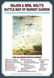
This is the only map of its kind devised and created by Major and Mrs Holt and is used by many guides   It shows the locations of 300 memorials and war cemeteries over THE WHOLE OPERATION MARKET-GARDEN AREA   It shows the progress of the battle from Leopoldsburg to  Eindhoven, Nijmegen, Arnhem and Oosterbeek overlaid on modern roads   In four colou...
9,95

Webshops met dit product

Webshop
Bezorging
Prijs

Anderen bekeken ook

Historische Kaart Major & Mrs Holt's Battle Map of Market Garden | Pen
This is the only map of its kind devised and created by Major and Mrs Holt and is used by many guides   It shows the locations of 300 memorials and war cemeteries over THE WHOLE OPERATION MARKET-GARDEN AREA   It shows the progress of the battle from Leopoldsburg to  Eindhoven, Nijmegen, Arnhem and Oosterbeek overlaid on modern roads   In four colours, double sided and with 10 inset maps it shows all drop and landing zones   Suitable for navigation by car, bicycle or foot   Size - The map measures 19.5 inches (49cm) by 28 inches (71cm). It is printed in four colours and is on firm glossy paper.   On one side at a scale of 1:180,000 is shown the whole of the Market Garden corridor of operations from Arnhem in the north to Leopoldsburg in the south and from Vught in the west to Overloon in the east. See below for details of the other side.   What is Marked on the Map   This map is quite unique and no other exists that shows the Market Garden Corridor in such detail. Over 230 memori…
9,95
Historische Kaart Major & Mrs Holt's Battle Map of The Somme | Pen and
This is the only map available that shows the exact locations of 300 memorials and places of interest on the battlefields of the Somme   This Sixth Edition also covers the American and Canadian areas between Amiens and Montdidier.    It is double sided in four colours with an overall view on one side and a detailed view on the other, both showing battle lines and ORBAT information   There are detailed alphabetical and thematic indexes to all 300 points.   Size - The map measures 19.5 inches (49cm) by 28 inches (71cm). It is printed in four colours and is double sided on firm glossy paper.   On one side at a scale of 1:70,000 is shown the whole of the Somme battle area from Bullecourt in the north to Amiens in the south and from Doullens in the west to Pyronne in the east. Also on this side are the colour coded indexes and the map of the 1918 sector from Villers Bretonneux to Cantigny.   On the other side at a scale of 1:40,000 the battle area mostly, but not exclusively, associate…
9,95
Historische Kaart Major & Mrs Holt's Battle Map of The Normandy D-Day
This is the only detailed battle map of the D-Day Beaches area that shows the locations of 400 memorials   The map is double sided showing the US beaches on one side and the British and Canadian on the other   It is in full colour with detailed thematic and alphabetical indexes making it easy to find what you are looking for.   Landing force details and battle lines are overlaid onto a grid of modern roads.   Size - The map measures 19.5 inches (49cm) by 28 inches (71cm).  It is printed in four colours and is on firm glossy paper.   On one side at a scale of 1:116,000 are shown The British Landing Beaches from Bayeux in the west to Ouistreham (covering GOLD,JUNO and SWORD) plus the 6th BR AB DZs from Pegasus Bridge to Dives.   On the other side at a scale of 1:116,000 are shown the US AE DZs around Ste Mere Eglise and Ste Marie du Mont and the US Landing Beaches, UTAH and OMAHA.   The Falaise Gap   There is also a small boxed section showing the area of Falaise and the locatio…
9,95
Historische Kaart Militair Erfgoed - In Flanders fields Belgium | NGI
Kaart voor militair erfgoed in West Vlaanderen, zowelvoor WO l als voor WO ll. The Western Front in Flanders on a detailed map at 1:100,000 highlighting locations of numerous monuments, cemeteries, front lines and other WWI-related sites, listed in the accompanying panels with, where appropriate, their phone numbers. The map is double-sided but all the main WWI battlefields from the French border to beyond Passendale/Paschendaele are together on one side.   The map shows the present-day road and rail networks in the province of West Flanders. Extensive overprint highlights locations of WWI-related sites, indicating whether open to the general public or by appointment only: museums, military cemeteries, war memorials and monuments to the missing soldiers, bunkers and battery remains, etc. Sites in France in the immediate vicinity of the Belgian border are also marked. The overprint also indicates battlefields and fortifications from other periods of history of Flanders, from the Middle …
8,50
Wegenkaart - landkaart Kgalagadi - Tourist Map of Kgalagadi Transfront
Zeer bijzondere landkaart van het grensgebied van Botswana en Zuid Afrika. Uitermate handig zijn de GPS coordinaten van de meest belangrijke punten als campings of uitzichtpunten. De kaart is gebaseerd op een luchtfoto, waarbij alle details zijn ingetekend. The map: The map consists of a large map of the entire Park on the front of the map. On the back is enlargements of six maps - the South African side, Mabuasehube, Swart Pan area, Gemsbok Wilderness Trail, Mabuasehube Wilderness Trail and of the Kaa Kalahari Concession. Satellite images were used and the roads were tracked by GPS. There are 168 GPS coordinates on this map. Establishment of a Transfrontier Park: On the 7 th of April 1999 Botswana and South Africa signed a bilateral agreement in which they agreed to manage their adjacent national parks, Gemsbok National Park in Botswana and Kalahari Gemsbok National Park in South Africa, as a single ecological unit – the Kgalagadi Transfrontier Park. It is the first formally declared …
17,50
Wegenkaart - landkaart Jersey - Guernsey - Sark - Alderney (Kanaaleila
Goede detailkaart van alle kanaaleilanden. Het is zo gedetailleerd dat zelfs straatnamen er op staan. De kaart is ook nog eens geplastificeerd en daarmee scheur- en watervast.  ITMB is pleased to re-introduce the Channel Islands map area after a lengthy hiatus of preparing new artwork. The first version of this part of Europe was licensed artwork by a local firm in Jersey, and upon running out of copies of the printed map, we opted to prepare fresh artwork of our own to continue this interesting corner of the continent to continue to be available. The islands, collectively known in English as the Channel Islands, are one of those anomalies that make Europe so attractive. They are part of Great Britain, but not part of the UK; hence, they are not part of the EU. They are self-governing entities ‘owned’ by the Queen in her role of being Duchess of Normandy. This is, of course, merely a hereditary situation, but the islands were the personal possessions of William the Conqueror in 1066, a…
13,95

Klanten-reviews van Historische Kaart Major & Mrs Holt's Battle Map of Market Garden | Pen

Er zijn nog geen beoordelingen voor dit productBen jij de eerste die een review plaatst?

Meer over Historische Kaart Major & Mrs Holt's Battle Map of Market Garden | Pen

Productomschrijving

This is the only map of its kind devised and created by Major and Mrs Holt and is used by many guides   It shows the locations of 300 memorials and war cemeteries over THE WHOLE OPERATION MARKET-GARDEN AREA   It shows the progress of the battle from Leopoldsburg to  Eindhoven, Nijmegen, Arnhem and Oosterbeek overlaid on modern roads   In four colours, double sided and with 10 inset maps it shows all drop and landing zones   Suitable for navigation by car, bicycle or foot   Size - The map measures 19.5 inches (49cm) by 28 inches (71cm). It is printed in four colours and is on firm glossy paper.   On one side at a scale of 1:180,000 is shown the whole of the Market Garden corridor of operations from Arnhem in the north to Leopoldsburg in the south and from Vught in the west to Overloon in the east. See below for details of the other side.   What is Marked on the Map   This map is quite unique and no other exists that shows the Market Garden Corridor in such detail. Over 230 memorials are clearly indicated as well as a dozen museums and 42 military cemeteries or military burial plots.   On the 1:180,000 side are indexes that cover that map and the inset maps of Leopoldsburg, Eindhoven and Vught. Overlaid on the map are the routes taken by the ground forces from the XXX Corps start line at Joe's Bridge on the Belgian border as well as the drop zones used by the British 1st Airborne Division and the American 101st and 82nd Airborne Divisions.   On the other side is a greatly expanded map of the Arnhem to Oosterbeek area showing the exact drop/landing zones for the British 1st Airborne Division and the routes taken forward towards the bridge over the Rhine. Inset into that map are detailed maps of the St Elisabeth Hospital area, the John Frost Bridge area and the Oosterbeek perimeter. Also on this side is a similarly expanded map showing the drop zones and movements of the American 82nd 'All American' Airborne Division from Groesbeek towards Nijmegen and with inset and indexed maps to Nijmegen and to Grave. On both sides is a base map showing modern roads thus making navigation simple.

Productspecificaties

Artikelnummer(s)
Brand
Pen and Sword publications

Verken gerelateerde categorieën

Shopblog.nl maakt gebruik van cookies. Ga je verder op onze website, ga dan akkoord met het plaatsen van cookies en de verwerking van deze data door ons en vermelde partners.