shopblog.nl
Categorieën
  Sluiten

Meer Editorial Alpina
Meer Editorial Alpina in Literatuur boeken

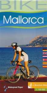
Fietskaart 75 Bike Mallorca | Editorial Alpina

Handige geplastificeerde fietskaart van Mallorca, met ingetekende routes, helder kaartbeeld en extra informatie aan de hand van symbolen.   This is a waterproof, folded map to the cycling Mecca of Mallorca. The scale is 1:100,000 and has English description.    Bike shops are listed and bike-friendly taxi services. Other practical information inclu...
9,95

Webshops met dit product

Webshop
Bezorging
Prijs

Anderen bekeken ook

Fietskaart 75 Bike Mallorca | Editorial Alpina
Handige geplastificeerde fietskaart van Mallorca, met ingetekende routes, helder kaartbeeld en extra informatie aan de hand van symbolen.   This is a waterproof, folded map to the cycling Mecca of Mallorca. The scale is 1:100,000 and has English description.    Bike shops are listed and bike-friendly taxi services. Other practical information includes average gradient symbols; routes graded for light/medium/heavy traffic; roads in bad repair; specific bike lanes; unpaved/dirt tracks. Suggested tours are highlighted, ranging from 36km to 110km, including height profiles.   Mountain bike routes are also marked on the map, most of which are unpaved and quite easy to follow.
9,95
Fietskaart Bike Costa Blanca | Editorial Alpina
Handige geplastificeerde fietskaart van Costa Blanca, met ingetekende routes, helder kaartbeeld en extra informatie aan de hand van symbolen.   Gebied: Jativa, Ontinyent, Agost, Benidorm.Javea, Gandia   This is a waterproof, folded map of Costa Blanca. The scale is 1:100,000 and has English description.    Bike shops are listed and bike-friendly taxi services. Other practical information includes average gradient symbols; routes graded for light/medium/heavy traffic; roads in bad repair; specific bike lanes; unpaved/dirt tracks. Suggested tours are highlighted, ranging from 36km to 110km, including height profiles.   Mountain bike routes are also marked on the map, most of which are unpaved and quite easy to follow.
12,50
Fietsgids Bikeline Danube Bike Trail 5 (Engels - Donau Radweg) | Ester
The fifth part of the Danube Bike Trail begins in Belgrade and ends in Romania on the Black Sea. With a total length of 2,845 kilometres, the Danube is Europe’s second longest river (after the Volga with 3,534 kilometres), and the only one on which kilometres are counted in reverse direction, starting with kilometer zero at the mouth and ending upstream at the source.   The total length of Part 5 of the Danube Bicycle Trail is about 1,400 kilometres. This does not include various side trips and alternative routes. The Danube Bike Trail is part of the Eurovelo-Route 6 and to a great extent identical.   This last part of the Danube Bike Trail mostly follows paved main roads and secondary roads, which you share with a variety of other traffic. It is not unusual in some parts of Bulgaria and Romania that you encounter more horse or mule carts, pedestrians or roaming sheep or geese than motorized traffic. In and around the larger cities, however, you can expect heavy traffic and you should …
15,50
Fietskaart 14 Cycling guides Suffolk | Goldeneye
To be confronted with the variety and complexity of the cycling routes, trails and paths in Suffolk can be a bewildering experience.  For it appears that the Suffolk County Council and the three District Councils are all trying hard to promote their areas. This is indeed encouraging for the growth of cycling, but it can be confusing.  Our purpose is to provide clear, easy to use and easy to follow, cycling maps, and to illustrate these in a comprehensive form.    Suffolk must be one of the most charming of counties to explore by bicycle. When Al Churcher delivered his routes to us at Goldeneye we couldn’t keep him quiet, such was his enthusiasm and wonder at Suffolk’s country lanes and byways. He has cycled all over the UK, Canada, Mallorca, New Zealand and Sicily, but Suffolk remained a firm favourite.    The inland scenery is not spectacular for the county’s main glory lies with its attractive villages; the local architecture jealously preserved from modern depredation. There is an a…
15,95
Fietskaart 01 Cycling guides Cornwall | Goldeneye
Our maps are double-sided, printed on an A2 sheet with a concertina fold. This allows for easy folding and folding, and an ease of access to the mapping. The material is rain and tear-resistant. Our early maps were designed at the scale of 2 miles to 1 inch/1:126,720. The later designs along with digitalisation are 1: 100,000. We were encouraged by the Cycle Touring Club to convert our cartography toward the cycle market (to replace the out-of-print Bartholomew series). As time and the series progressed we have added more data: The National Cycle Network routes, Regional Routes, and Traffic-Free Family Routes, as and when they are developed. These routes are in addition to the Circular Routes Goldeneye Commissioned at the outset of our publishing schedule. We are also adding to new editions; bike shops, cycle hire, and tea rooms, along with the tourist attractions already featured. Our plan is to make available digital versions for cell phones and tablets and to update, on an annual ba…
15,95
Wandelgids Mallorca | Sunflower books
Wandelgids: vele dagtochten worden degelijk beschreven met openbaar vervoer informatie, goede routebeschrijvingen en kaartmateriaal. Tevens enkele autotochten. Deze gids staat goed bekend! Engelstalig, want nederlandstalige is uitverkocht en niet meer leverbaar. The go-to Mallorca travel guide for over 30 years. Strap on your boots and discover Mallorca on foot with the Sunflower Mallorca travel guide. And on the days when your feet may have had enough, enjoy some spectacular scenery on one of our legendary car tours.   The Sunflower Mallorca guide is indispensable for hiking in Mallorca or seeing Mallorca by car. This was the first walking guide for Mallorca, the guide that won Sunflower the Sunday Times 'Oscar' for best travel guide - and eventually made the island one of the most popular walking areas in Europe.The author has lived on Mallorca for over 35 years and knows the island intimately. She has also been able to recheck most of the routes - as well as adding several new wa…
23,95

Klanten-reviews van Fietskaart 75 Bike Mallorca | Editorial Alpina

Er zijn nog geen beoordelingen voor dit productBen jij de eerste die een review plaatst?

Meer over Fietskaart 75 Bike Mallorca | Editorial Alpina

Productomschrijving

Handige geplastificeerde fietskaart van Mallorca, met ingetekende routes, helder kaartbeeld en extra informatie aan de hand van symbolen.   This is a waterproof, folded map to the cycling Mecca of Mallorca. The scale is 1:100,000 and has English description.    Bike shops are listed and bike-friendly taxi services. Other practical information includes average gradient symbols; routes graded for light/medium/heavy traffic; roads in bad repair; specific bike lanes; unpaved/dirt tracks. Suggested tours are highlighted, ranging from 36km to 110km, including height profiles.   Mountain bike routes are also marked on the map, most of which are unpaved and quite easy to follow.

Productspecificaties

Artikelnummer(s)
Brand
Editorial Alpina

Verken gerelateerde categorieën

Shopblog.nl maakt gebruik van cookies. Ga je verder op onze website, ga dan akkoord met het plaatsen van cookies en de verwerking van deze data door ons en vermelde partners.