shopblog.nl
Categorieën
  Sluiten

Meer Freytag & Berndt

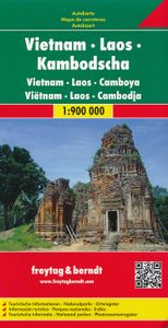
Wegenkaart - landkaart Vietnam - Laos - Cambodia (Cambodja) | Freytag

Zeer goede overzichtskaart van het hele gebied van Vietnam, Laos en Cambodja. Zeker als je meerdere landen gaat combineren is dit een prima kaart waar nog veel op staat. Veel plaatsen, maar ook allerlei toeristisch interessante plekken die met symbolen zijn aangegeven. Detailed, double-sided road map Vietnam, Cambodia, and Laos, ideal for route-pla...
14,95

Webshops met dit product

Webshop
Bezorging
Prijs

Anderen bekeken ook

Wegenkaart - landkaart Vietnam - Laos - Cambodia (Cambodja) | Freytag
Zeer goede overzichtskaart van het hele gebied van Vietnam, Laos en Cambodja. Zeker als je meerdere landen gaat combineren is dit een prima kaart waar nog veel op staat. Veel plaatsen, maar ook allerlei toeristisch interessante plekken die met symbolen zijn aangegeven. Detailed, double-sided road map Vietnam, Cambodia, and Laos, ideal for route-planning. Clearly shows the national road network and selected provincial and local roads, with each class of road clearly indicated and road numbers shown. Intermediate driving distances between locations are shown in kilometres alongside the road, motorway filling stations are shown and motorway junctions are indicated. Topography is shown with relief shading and some spot heights. International and provincial boundaries are clearly marked, as are National Parks, nature reserves and restricted military areas. Symbols indicate various sights & locations of tourist interest, such as churches, leisure & sports destinations, panoramas & viewing po…
14,95
Wegenkaart - landkaart 770 Vietnam - Laos - Cambodja | Michelin
Zoals je van Michelin mag verwachten is deze kaart zeer overzichtelijk en heeft een duidelijk helder kaartbeeld. De kaart geeft uitgebreide toeristische informatie weer. De perfecte overzichtskaart!   This Vietnam - Laos - Cambodia map from Michelin is part of their red national map series. These are perfect for route planning as well as getting around by car once you're there. They clearly mark out major roads and also show many of the more important minor roads. A street plan of central Lima that highlights the city's mai attractions is included.   The map's simple folding design with durable paper cover, allows it to be read like a book and easily folded back together. Road numbers and intermediate distances are clearly displayed with the more scenic routes highlighted in green.   The map also features:   Political boundaries Regional and National Parks Important sights (points of interest, historic sites, etc.) Driving Times and Distances Road Safety Information A legend in multipl…
12,95
Wegenkaart - landkaart Bali - Lombok - Komodo | Freytag & Berndt
Goede duidelijke wegenkaart aan twee kanten bedrukt. Alle details staan er op! Met toeristische informatie, Nationale Parken en een index. Detailed, double-sided road map of Bali, Lombok and Komodo islands. Clearly shows the national road network and selected provincial and local roads, with each class of road clearly indicated and road numbers shown. Intermediate driving distances between locations are shown in kilometres alongside the road, motorway filling stations are shown and motorway junctions are indicated. Topography is shown with relief shading and some spot heights, and colour shading is used to indicate land types such as forests or marshland. International and provincial boundaries are clearly marked, as are National Parks, nature reserves and restricted military areas. Symbols indicate various sights & locations of tourist interest, such as churches, leisure & sports destinations, panoramas & viewing points, monuments and historic sites. Some hotels and campsites are mark…
14,95
Wegenkaart - landkaart Vietnam - Laos - Cambodia | ITMB
Een degelijke kaart met aanduidingen van o.a. nationale parken, vliegveld, benzinepomp, dirt-roads. Als overzichtskaart goed te gebruiken. The former French-dominated region of Indochina evolved into three separate countries in the early 1950s. Vietnam, Laos, and Cambodia still retain strong ties and it is easy to travel from one country to another. Each has its particular charm, with a Top Attractions list highlighting the most popular attractions. Side 1 concentrates on the southern portion of the region and includes an inset map of Ho Chi Minh City; the second side covers the area from Sien Riep in Cambodia to the Chinese border areas of both Laos and Vietnam. An inset map of Hanoi is one this side. The region is prospering after many years of civil unrest, is friendly, safe, and easy to reach since Covid restrictions were removed last year. The new Chinese-built rail line through northern Laos to Chiang Kong in Thailand, and to Vientiane, Laos, is shown for the first time. This lin…
13,95
Wegenkaart - landkaart Tsjechië - Tschechische Republik | Freytag & Be
Uitstekende kaart van heel Tsjechië. Met index, toeristische informatie en afstanden in kilometers, dubbelzijdig. De berijdbare wegen zijn goed weergeven, zowel de hoofdwegen als provinciale en lokale wegen; wegnummers worden vermeld. Afstanden tussen plaatsen zijn in kilometers op de kaart ingetekend, daarnaast worden ook op belangrijke plekken benzinepompen gemarkeerd.   In het kaartbeeld wordt door middel van schaduw het reliëf weergegeven en soms enkele punten in het landschap met de daadwerkelijke hoogte. Provinciegrenzen zijn goed terug te vinden, nationale parken en reservaten ook. Met allerhande symbolen worden toeristische bezienswaardigheden weergegeven als monumenten, historisch belangrijke plekken en uitzichtpunten. In bepaalde plaatsen zijn hotels en campings te vinden, luchthavens, treinverbindingen vindt u er ook op! Czech Republic road map from Austrain publisher Freytag and Berndt, at a scale of 1:250,000 comes with an index booklet complete with postcode information. …
14,95
Wegenkaart - landkaart 3024 Adventure Map Cambodia - Cambodja | Nation
Mooie, heldere kaart van Cambodja,  gedrukt op scheurvast en watervast papier. National Geographic's Cambodia Adventure Map is designed to meet the needs of adventure travelers with its durability and detailed, accurate information. This map includes the locations of cities and towns with a user-friendly index, a clearly marked road network complete with distances and designations for roads/highways, plus secondary routes for those seeking to explore off the beaten path. Adventure Maps differ from a traditional road map because of the specialty content they include. Each map contains hundreds of diverse and unique recreational, ecological, cultural, and historic destinations — outside of the major tourist hubs. National Geographic Adventure Maps are the perfect companion to a guidebook, yet far easier to pack!   Cambodia is perhaps best know to international travelers as the home of the Angkor empire for six hundred years. Angkor Wat and Angkor Thom are part of the vast temple complex …
17,50

Klanten-reviews van Wegenkaart - landkaart Vietnam - Laos - Cambodia (Cambodja) | Freytag

Er zijn nog geen beoordelingen voor dit productBen jij de eerste die een review plaatst?

Meer over Wegenkaart - landkaart Vietnam - Laos - Cambodia (Cambodja) | Freytag

Productomschrijving

Zeer goede overzichtskaart van het hele gebied van Vietnam, Laos en Cambodja. Zeker als je meerdere landen gaat combineren is dit een prima kaart waar nog veel op staat. Veel plaatsen, maar ook allerlei toeristisch interessante plekken die met symbolen zijn aangegeven. Detailed, double-sided road map Vietnam, Cambodia, and Laos, ideal for route-planning. Clearly shows the national road network and selected provincial and local roads, with each class of road clearly indicated and road numbers shown. Intermediate driving distances between locations are shown in kilometres alongside the road, motorway filling stations are shown and motorway junctions are indicated. Topography is shown with relief shading and some spot heights. International and provincial boundaries are clearly marked, as are National Parks, nature reserves and restricted military areas. Symbols indicate various sights & locations of tourist interest, such as churches, leisure & sports destinations, panoramas & viewing points, monuments and historic sites. Some hotels and campsites are marked. Railway lines, airports, ports, reefs and marinas are also shown. A grid divides the map at 1° increments, and is also grid-referenced for the map index. Multilingual map legend includes English.

Productspecificaties

Artikelnummer(s)
Brand
Freytag & Berndt
Shopblog.nl maakt gebruik van cookies. Ga je verder op onze website, ga dan akkoord met het plaatsen van cookies en de verwerking van deze data door ons en vermelde partners.