shopblog.nl
Categorieën
  Sluiten

Meer Collins

Historische Kaart Scotland Clans and Tartans Map | Collins

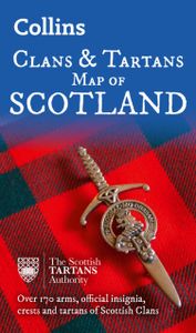
Prachtige kaart van Schotland waarin duideljk wordt welke cland er zijn geweest en nog zijn. Met een mooi overzicht van alle Tartans (Stoffen) die er aan gekoppeld zijn.    Discover Scotland with this authoritative guide to clans, tartans, and their origins. These popular maps are highly detailed, showing hundreds of arms, official insignia, crests...
8,50

Webshops met dit product

Webshop
Bezorging
Prijs

Anderen bekeken ook

Historische Kaart Scotland Clans and Tartans Map | Collins
Prachtige kaart van Schotland waarin duideljk wordt welke cland er zijn geweest en nog zijn. Met een mooi overzicht van alle Tartans (Stoffen) die er aan gekoppeld zijn.    Discover Scotland with this authoritative guide to clans, tartans, and their origins. These popular maps are highly detailed, showing hundreds of arms, official insignia, crests, and tartans of the Scottish clans. This beautifully illustrated map is both decorative and informative.   This map includes: Two double-sided, full-colour maps of ScotlandMore than 170 arms, the official insignia of clan chiefs, crest badges, and the locations of their ancient territories around the time of King James VIMore than 240 tartans with corresponding clan/ family names, alphabetically arranged for easy look-upAdditional information about the history of the clans and their tartans The map is ideal for those those with an interest in Scottish heraldry, clans and family history. Other titles in the series include:* Castles Map of Sco…
8,50
Historische Kaart Tartans Map of Scotland | Collins
Discover Scotland with this authoritative guide to tartans and their origins. This popular touring map has a huge amount of detail with over 1,000 places of tourist interest plotted and named on the map. The features have been plotted onto an up-to-date and attractive Collins map of Scotland.   A clear, easy to follow road map with colour classified roads. Ideal for tourists with hundreds of distinctive tourist symbols and tourist information centres all shown. This map includes:* The whole of Scotland on a double sided sheet at 5 miles to 1 inch* Over 25 categories of tourist information shown on the map including youth hostels, picnic sites and ferries as well as the more obvious tourist sites such as castles, wildlife parks and museums* Detailed town centre maps of Edinburgh, Glasgow, Aberdeen, Dundee, Inverness and Perth* Distances on the map along major routes Scale: 1:316,800 (5 miles to 1 inch).   There is a comprehensive index to both place names and places of tourist interest.
8,50
Wegenkaart - landkaart Castles map of Scotland - Schotland kastelen |
Kaart waarop meer dan 700 kastelen in Schotland staan aangegeven. Discover Scotland's ancient monuments and castles. Explore Scotland’s ancient monuments with this pictorial map featuring over 700 castles and fortified houses. Includes an easy-to-use index listing visitor information and an attractive selection of photographs.   The map includes: • Over 700 castles and fortications • Index comprises map references, the age and type of each castle, public access details, Historic Scotland and National Trust for Scotland ownership, notable grounds and gardens, telephone numbers and websites • Highlights Scotland’s finest castles, castellated mansions and also the best castles for children • Attractive photographs of a selection of castles, together with a brief account of their history • A brief history of Scottish castles and information on architectural types and periods of construction • Internet links and suggested reading for further information   Scotland is a country a…
13,95
Wegenkaart - landkaart Whisky map of Scotland | Collins
Wegenkaart met meer dan 100 distilleerderijen en whisky gerelateerde locaties.   Discover where Scotland’s national drink is produced. All of Scotland’s operational whisky distilleries and whisky-related places of interest located on one map. Also includes an easy-to-use index listing visitor facilities, contact details and websites. The map includes:   • Over 100 distilleries and whisky-related places of interest • Insert map of malt whisky areas • A photographic guide to how whisky is made • Selection of labels of blended Scotch whisky brands • Did you know? Section with interesting facts • World maps of main export markets • Index lists visitor facilities, telephone numbers and websites   Scotch whisky is unique among national drinks – synonymous with Scotland, it cannot be produced elsewhere in the world.   Other titles in the series: Castles Map of Scotland, Tartans Map of Scotland, Scotland of Old Clans Map
9,95
Spoorwegenkaart Schotland - Scotland Central and South Rail and Road |
Een degelijke kaart met aanduidingen van o.a. spoorlijnen, nationale parken, vliegveld, benzinepomp, dirt-roads en kleine plattegrond van hoofdstad. Als overzichtskaart goed te gebruiken. This is another new ITMB title and extends our sectional coverage of the UK northwards from the southernmost border at Gretna Green through the densely-populated Glasgow/Edinburgh/Stirling conurbation to the highlands. The reason for this sectional map is to provide additional space to show 25% more detail than our map of all of Scotland can provide. The north of Scotland is my favourite part of the country, but there isn’t much there except heather and single-lane tracks across treeless moors. The South, like it or not, is where most of Scotland’s four million people live and where most of the castles, palaces, battlefields, parks, and touristic attractions are located. The map also shows the ferry routes to the outer islands of Arran and Mull, and the most poignant battlefield I’ve ever visited, Cul…
13,95
Wegenkaart - landkaart Touring Map of Scotland - Schotland | Collins
Best-selling map of Scotland. More than 1,000 places of tourist interest plotted and named on the map. The features have been plotted onto an up-to-date and attractive Collins map of Scotland.   A clear, easy to follow road map with colour classified roads. Ideal for tourists with hundreds of distinctive tourist symbols and tourist information centres all shown.   This map includes: • The whole of Scotland on a double sided sheet at 5 miles to 1 inch • Over 25 categories of tourist information shown on the map including youth hostels, picnic sites and ferries as well as the more obvious tourist sites such as castles, wildlife parks and museums • Detailed town centre maps of Edinburgh, Glasgow, Aberdeen, Dundee, Inverness and Perth • New places of interest including Japanese Garden (near Dollar), Macallan Distillery Centre, Moat Brae (Dumfries) and Scottish Submarine Centre (Helensburgh) • Road updates include the new Dalry bypass, Maybole bypass under construction, A9 dualling sections…
9,95

Klanten-reviews van Historische Kaart Scotland Clans and Tartans Map | Collins

Er zijn nog geen beoordelingen voor dit productBen jij de eerste die een review plaatst?

Meer over Historische Kaart Scotland Clans and Tartans Map | Collins

Productomschrijving

Prachtige kaart van Schotland waarin duideljk wordt welke cland er zijn geweest en nog zijn. Met een mooi overzicht van alle Tartans (Stoffen) die er aan gekoppeld zijn.    Discover Scotland with this authoritative guide to clans, tartans, and their origins. These popular maps are highly detailed, showing hundreds of arms, official insignia, crests, and tartans of the Scottish clans. This beautifully illustrated map is both decorative and informative.   This map includes: Two double-sided, full-colour maps of ScotlandMore than 170 arms, the official insignia of clan chiefs, crest badges, and the locations of their ancient territories around the time of King James VIMore than 240 tartans with corresponding clan/ family names, alphabetically arranged for easy look-upAdditional information about the history of the clans and their tartans The map is ideal for those those with an interest in Scottish heraldry, clans and family history. Other titles in the series include:* Castles Map of Scotland (99780007508532)* Whiskey Map of Scotland (9780008368319)d of Old Clans Map

Productspecificaties

Artikelnummer(s)
Brand
Collins
Shopblog.nl maakt gebruik van cookies. Ga je verder op onze website, ga dan akkoord met het plaatsen van cookies en de verwerking van deze data door ons en vermelde partners.